Science
Hurricane Erin Becomes Historic Category 5 Storm in Atlantic
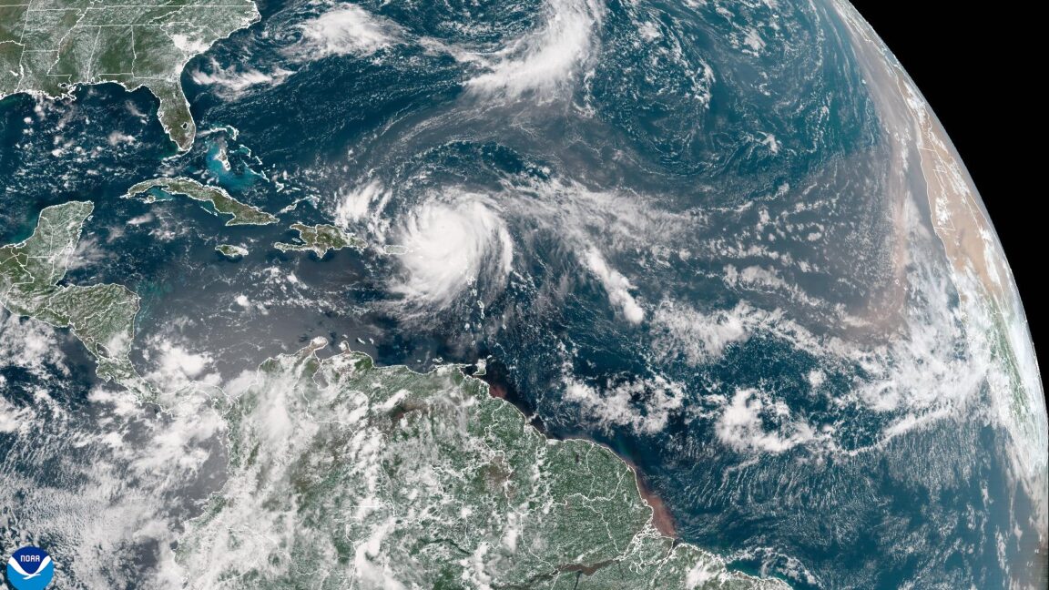
Hurricane Erin intensified dramatically over the course of a few days, reaching Category 5 status on Saturday, September 2, 2023. The National Hurricane Center confirmed this classification following measurements taken by a US Air Force Hurricane Hunter aircraft, which recorded sustained winds of 160 mph. This marks Erin as the most powerful hurricane of the Atlantic season, which has been notably slow to develop this year.
The storm is currently navigating north of the Caribbean islands and is projected to maintain a path that avoids direct impact with land. Forecasts indicate that Erin will turn northward, skirting past the Bahamas and the Eastern United States before heading toward a trajectory between Atlantic Canada and Bermuda. Meteorologists express a reasonable degree of confidence in this forecast, as predictive models have shown consistent outputs.
Record-Breaking Intensification
Erin’s rapid intensification is significant and alarming. It transitioned from a tropical storm to a hurricane just after 11:00 AM ET on Friday, September 1, and has since undergone unprecedented growth. According to meteorologist Sam Lillo, the storm deepened by a remarkable 70 millibars within 24 hours, making it the most rapidly intensifying hurricane recorded in the Atlantic before September 1. With a central pressure of 917 mb, Erin is now the second-most intense Atlantic hurricane in the past 50 years for this date, surpassed only by Hurricane Allen in 1980.
While Erin’s current path appears to spare land from catastrophic damage, the rapidity of its intensification raises concerns among scientists and climate experts. Research shows a trend toward more frequent and severe storms as a result of climate change. A study published in Nature Communications found that intensification rates for the strongest 5 percent of Atlantic hurricanes have increased by approximately 3-4 mph per decade from 1982 to 2009.
Climate Change and Future Storms
Experts agree that the overall number of tropical storms may not rise significantly in a warming climate, but the intensity of storms like Erin is projected to increase. According to the US government’s Climate.gov, the percentage of severe tropical cyclones, classified as Category 4 and 5, has risen, potentially due to human-induced climate change. The report indicates that this trend is likely to continue, resulting in storms with more damaging wind speeds, higher storm surges, and extreme rainfall.
Despite experiencing lower overall activity in the tropical Atlantic this year, Erin’s intensity suggests the season could soon reach normal levels of Accumulated Cyclone Energy, a metric used to evaluate a season’s total activity. The peak of the Atlantic hurricane season typically occurs in early September, with the majority of storms forming between early August and early October. Forecast models predict the possible development of additional hurricanes in the coming weeks, although uncertainty remains regarding their potential impact on land.
As Hurricane Erin continues its course, the focus remains on monitoring its trajectory and intensity while acknowledging the broader implications of climate change on future storm patterns.


DIY Houseboat “Neverlanding” Docks in Michigan After Epic Journey

Man Awaits Sentencing After Stabbing TTC Rider, Victim Critical

Vancouver Man Wins $500,000 Lottery, Plans Condo Purchase Now

United Airlines Reduces Boeing 777 Flight Schedule for December

Judges’ Association Challenges Government Over $28K Pay Increase Denial

Veteran Ed Martin Champions Community Service Through Volunteering

Mission Hill Family Estate Ranked Among World’s 50 Best Vineyards

Quantum Computers Set to Revolutionize Drug and Fertilizer Development

Teen Mental Health Crisis Surges, Driven by Distress and School Policies

Secwepemc First Nation Seeks Aboriginal Title Over Kamloops Area

Scientists Unearth Ancient Antarctic Ice to Unlock Climate Secrets

Trump and McCormick to Announce $70 Billion Energy Investments

Four Astronauts Return to Earth After International Space Station Mission
TransLink Launches Food Truck Program to Boost Revenue in Vancouver

Apple Notes Enhances Functionality with Markdown Support in macOS 26

Manitoba’s Burger Champion Shines Again Amid Dining Innovations

Urgent Update: Fatal Crash on Highway 99 Claims Life of Pitt Meadows Man

Ukrainian Tennis Star Elina Svitolina Faces Death Threats Online
-
 Politics4 weeks ago
Secwepemc First Nation Seeks Aboriginal Title Over Kamloops Area
-
 World5 months ago
Scientists Unearth Ancient Antarctic Ice to Unlock Climate Secrets
-
 Entertainment5 months ago
Trump and McCormick to Announce $70 Billion Energy Investments
-
 Science5 months ago
Four Astronauts Return to Earth After International Space Station Mission
-

 Lifestyle5 months ago
TransLink Launches Food Truck Program to Boost Revenue in Vancouver
-
 Technology3 months ago
Apple Notes Enhances Functionality with Markdown Support in macOS 26
-
 Lifestyle3 months ago
Manitoba’s Burger Champion Shines Again Amid Dining Innovations
-
 Top Stories2 months ago
Urgent Update: Fatal Crash on Highway 99 Claims Life of Pitt Meadows Man
-
 Politics4 months ago
Ukrainian Tennis Star Elina Svitolina Faces Death Threats Online
-

 Sports5 months ago
Search Underway for Missing Hunter Amid Hokkaido Bear Emergency
-

 Politics5 months ago
Carney Engages First Nations Leaders at Development Law Summit
-

 Technology5 months ago
Frosthaven Launches Early Access on July 31, 2025