Top Stories
Weather Bomb Set to Strike Newfoundland with Heavy Rain, Winds
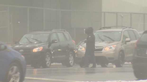
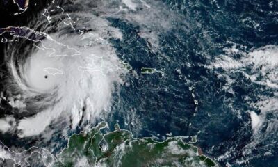
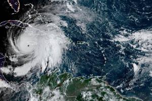
UPDATE: A powerful “weather bomb” is poised to impact Newfoundland, with severe weather conditions expected to begin Tuesday afternoon. Environment Canada has issued urgent weather alerts for the Avalon and Burin peninsulas, as well as for coastal Labrador, warning residents of potential hazards from high winds and heavy rainfall.
According to CBC meteorologist Ashley Brauweiler, winds are forecasted to gust up to 110 km/h on Tuesday, with dangerous conditions persisting into Wednesday night. This storm system is characterized as an “incredibly strong northeaster,” and residents are urged to take precautions.
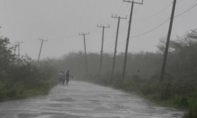
Significant rainfall is set to begin on Tuesday morning, impacting the entire island. Areas can expect between 50 mm and 70 mm of rain, heightening the risk of coastal flooding. Brauweiler emphasized that waves could reach alarming heights of up to six to nine metres, particularly along the south coast, which may lead to hazardous conditions if waters surpass high tide.
Environment Canada has also issued special weather statements for various parts of Newfoundland and Labrador, highlighting the potential for coastal flooding due to storm surges. The anticipated rainfall could accumulate to 50 mm within a 24-hour period, with possible snow in inland areas.
“This is going to be an incredibly strong northeaster,” said Brauweiler, urging residents to remain vigilant.
As a precautionary measure, Marine Atlantic has already cancelled all crossings scheduled for Tuesday and Wednesday morning. The company stated, “While this fall season has been relatively calm from a weather perspective, this has been an active week following this past weekend’s disruptions and the two upcoming storms. We will continue to provide customers with the latest updates throughout the week as information becomes available.”
The storm is expected to weaken by Wednesday night or Thursday morning, but coastal Labrador may continue to experience effects from the weather system through to Friday. Residents are advised to stay informed and monitor local news for the latest updates on this developing situation.
As this weather bomb approaches, the urgency for preparedness cannot be overstated. Ensure you have necessary supplies on hand and stay tuned to reliable sources for real-time updates.


B.C. Premier Eby Cancels U.S. Anti-Tariff Ads Amid Tensions

Urgent Update: Aquatic Activity Surges as Autumn Temperatures Drop

Belleville Police Confirm Resolution of 25-Year-Old Sexual Assault Case

New Brunswick Boosts Healthcare Workforce with 400 Nurses, 80 Physicians

West Lethbridge Unveils Over $300M in Major Development Projects

JBL Tune 510BT Headphones on Sale for $29.95 – A Great Deal

Chicago Bears Triumph Over Bengals in Thrilling 47-42 Victory

Rock Falls High School Achieves Record Graduation Rates in 2025

North Vancouver Unveils $21M Oceanfront Swimming Platform by 2027

Scientists Unearth Ancient Antarctic Ice to Unlock Climate Secrets

Trump and McCormick to Announce $70 Billion Energy Investments
TransLink Launches Food Truck Program to Boost Revenue in Vancouver

Four Astronauts Return to Earth After International Space Station Mission

Apple Notes Enhances Functionality with Markdown Support in macOS 26

Urgent Update: Fatal Crash on Highway 99 Claims Life of Pitt Meadows Man

Search Underway for Missing Hunter Amid Hokkaido Bear Emergency

Ukrainian Tennis Star Elina Svitolina Faces Death Threats Online

Carney Engages First Nations Leaders at Development Law Summit
-
 World4 months ago
Scientists Unearth Ancient Antarctic Ice to Unlock Climate Secrets
-
 Entertainment4 months ago
Trump and McCormick to Announce $70 Billion Energy Investments
-

 Lifestyle4 months ago
TransLink Launches Food Truck Program to Boost Revenue in Vancouver
-
 Science4 months ago
Four Astronauts Return to Earth After International Space Station Mission
-
 Technology2 months ago
Apple Notes Enhances Functionality with Markdown Support in macOS 26
-
 Top Stories3 weeks ago
Urgent Update: Fatal Crash on Highway 99 Claims Life of Pitt Meadows Man
-
 Sports4 months ago
Search Underway for Missing Hunter Amid Hokkaido Bear Emergency
-
 Politics3 months ago
Ukrainian Tennis Star Elina Svitolina Faces Death Threats Online
-
 Politics4 months ago
Carney Engages First Nations Leaders at Development Law Summit
-

 Technology4 months ago
Frosthaven Launches Early Access on July 31, 2025
-

 Top Stories2 weeks ago
Family Remembers Beverley Rowbotham 25 Years After Murder
-

 Top Stories5 days ago
Blake Snell’s Frustration Ignites Toronto Blue Jays Fan Fury