ESA’s Biomass satellite has released its first breathtaking images of Earth, providing a never-before-seen perspective of the planet’s most intact and ecologically significant regions. Unveiled at the Living Planet Symposium 2025 in Vienna, these images reveal not just forests, but also deserts and glaciers, showcasing the satellite’s potential to transform environmental monitoring. Despite being in its early commissioning phase, Biomass has already surpassed expectations with its radar capabilities, which are poised to deliver critical data about carbon storage and the impacts of climate change.
A New Chapter in Earth Observation
The Biomass satellite is a game changer for environmental science, with its state-of-the-art radar system that uses P-band technology to penetrate thick canopies, ice, and soil. Unlike optical satellites that only capture surface features, Biomass’s radar can measure forest biomass in three dimensions, giving scientists an unparalleled view of forest structure.
“These first images are nothing short of spectacular — and they’re only a mere glimpse of what is still to come,” said Michael Fehringer, ESA’s Biomass Project Manager.
These first results, which include detailed views of tropical rainforests, the Amazon Basin, and the frozen Antarctic regions, demonstrate the immense power of Biomass to monitor carbon storage and climate dynamics.
In addition to its ability to measure the vertical structure of forests, Biomass is also capable of providing valuable insights into desert and ice-covered regions. This dual capability opens new frontiers for scientific research, enabling more precise assessments of Earth’s changing ecosystems. The early success of Biomass marks the beginning of a mission designed to provide vital data on forest health, climate change, and carbon cycles for at least five years.
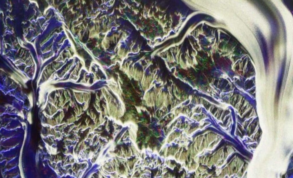
Biomass satellite view of the Nimrod Glacier. (Image credit: ESA)
A Symbol of Collaborative Effort and Innovation
The release of these first images was a milestone not just in space exploration, but also in international collaboration.
“It was extremely emotional because it was the work of hundreds of people,” said Simonetta Cheli, ESA’s Director of Earth Observation Programmes. “It’s very symbolic of the effort behind the scenes and the potential that this mission has.”
Biomass’s ability to offer new insights into Earth’s most important ecosystems is a result of years of tireless work from a global network of scientists, engineers, and researchers dedicated to understanding our planet’s environment.
The mission’s success highlights the power of cooperation in addressing global challenges like climate change and environmental degradation. By leveraging innovative space technologies, ESA is providing the scientific community with tools that will shape the future of conservation and sustainability efforts worldwide.
The Power of Radar: Biomass Captures Unseen Details
Biomass’s radar system offers an extraordinary ability to “see” through forests, ice, and soil, capturing the hidden structures that are invisible to optical satellites. This is particularly evident in the first images, which showcase the Amazon rainforest and the Beni River in Bolivia. The radar reveals not just the forest canopy, but also the underlying forest structure, giving a 3D view of the landscape. This ability is critical for accurately measuring the amount of carbon stored in forests, an essential component of global climate models.
The tropical forests of Bolivia, one of the first regions captured by Biomass, have been significantly impacted by deforestation in recent years. The image shows the Beni River meandering through lush rainforests and forested wetlands, highlighting the diverse ecosystems that depend on this region. Biomass’s ability to distinguish between various types of vegetation, such as forests, wetlands, and grasslands, is a powerful tool in understanding the effects of deforestation on biodiversity and carbon sequestration.
A comparison of two images of the Bolivian landscape, the above captured by the Sentinel-2 satellite and the below by Biomass. (Image credit: ESA)
Exploring the World’s Extreme Environments
Biomass is not limited to tropical forests; it is equally adept at observing some of the most remote and extreme environments on Earth. In the Sahara Desert, the satellite’s radar revealed hidden geological structures beneath the shifting sands, including ancient riverbeds and land formations. This capability could play a crucial role in paleoclimate studies and groundwater mapping, opening new possibilities for understanding how deserts have evolved over time.
The Biomass satellite view of the Sahara Desert in Chad reveals structures below the sand. (Image credit: ESA)
In Antarctica, the radar penetrates the thick ice sheets, revealing internal structures and helping scientists monitor the stability of ice flow and glaciers. These insights are vital for understanding sea-level rise and the future impacts of climate change on polar regions. The ability to track ice dynamics in real time makes Biomass an invaluable tool in assessing the effects of global warming on Earth’s frozen landscapes.
The announcement comes as the global community is increasingly focused on climate change and environmental sustainability. The Biomass satellite represents a significant leap forward in our ability to monitor and understand the planet’s most critical ecosystems. As the mission progresses, the data collected will undoubtedly play a crucial role in shaping future environmental policies and conservation strategies worldwide.