Top Stories
Urgent Weather Alert: Rain Turns to Snow as December Approaches
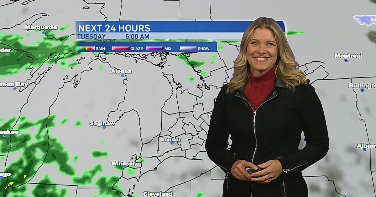
URGENT UPDATE: A significant weather shift is underway as rain transitions to snow across southern Ontario, just in time for December. Meteorologist Julie Atchison from CTV News London warns that showers are expected to intensify this afternoon, with a 40 percent chance of precipitation early today and increasing likelihood as temperatures begin to plummet.
Authorities confirm that cold air will sweep into the region starting Wednesday night, bringing a major change in weather conditions. “We will start to usher in December with colder temperatures and the risk for flurries,” Atchison noted. The forecast indicates potential for snow squalls, particularly in Grey and Bruce County through the week.
Residents should prepare for what may become a multi-day snow squall event for London, with the heaviest snowfall expected in midwestern Ontario. “As temperatures drop, it will get windy. If the weather system aligns perfectly over Lake Huron, we could see significant snow squalls,” Atchison added. The urgency of this forecast cannot be overstated, as this drastic change may impact travel and daily activities.
Here’s what to expect in detail:
Today: Cloudy with a few early showers. Winds shifting southeast at 20 km/h by noon, with a high of 10°C.
Tonight: Cloudy with a 40 percent chance of showers or drizzle. Expect fog patches to dissipate before morning. Winds will shift southwest at 20 km/h, gusting to 40 km/h near midnight, with a low of 9°C.
Wednesday: Showers ending by noon, then cloudy. Winds increasing southwest at 30 km/h, gusting up to 70 km/h near noon, with a high of 11°C.
Thursday: Cloudy with a 30 percent chance of flurries. Windy conditions will lead to a high of zero degrees.
Friday: Expect similar conditions with a 30 percent chance of flurries and a high of zero degrees.
Saturday: Cloudy skies persist with a 30 percent chance of flurries and a high of minus 2°C.
Sunday: The forecast remains cloudy with a heightened chance of rain showers or flurries at 60 percent and a high of plus 2°C.
Residents are urged to stay updated on local weather alerts and prepare for rapidly changing conditions. With winter officially approaching, this forecast serves as a reminder of the unpredictable nature of the season. Stay safe and informed as we enter a potentially challenging weather week.


Urgent: Major Crash Blocks Eastbound Hwy. 401 Near Oshawa

Tiny Homes Developer Seeks Court Exemption from Landlord Rules

Quebec’s Les Furies Roller Derby Comedy Celebrates Women in Sports

Horoscope Insights: Mercury Retrograde Ends on November 28

Nurses Vote to Grey List Thompson Hospital Amid Rising Violence

Scammers Target Holiday Shoppers with New Remote Access Trick

Innovative 3D-Printed Lamps Bring Coral-Inspired Light to Life

Ontario Government Reviews College Funding Amid $1.8B Crisis

Manitoba Nurses Vote 97% to Grey List Thompson Hospital Amid Violence

Secwepemc First Nation Seeks Aboriginal Title Over Kamloops Area

Scientists Unearth Ancient Antarctic Ice to Unlock Climate Secrets

Trump and McCormick to Announce $70 Billion Energy Investments
TransLink Launches Food Truck Program to Boost Revenue in Vancouver

Four Astronauts Return to Earth After International Space Station Mission

Apple Notes Enhances Functionality with Markdown Support in macOS 26

Urgent Update: Fatal Crash on Highway 99 Claims Life of Pitt Meadows Man

Manitoba’s Burger Champion Shines Again Amid Dining Innovations

Ukrainian Tennis Star Elina Svitolina Faces Death Threats Online
-
 Politics3 weeks ago
Secwepemc First Nation Seeks Aboriginal Title Over Kamloops Area
-
 World4 months ago
Scientists Unearth Ancient Antarctic Ice to Unlock Climate Secrets
-
 Entertainment5 months ago
Trump and McCormick to Announce $70 Billion Energy Investments
-

 Lifestyle4 months ago
TransLink Launches Food Truck Program to Boost Revenue in Vancouver
-
 Science5 months ago
Four Astronauts Return to Earth After International Space Station Mission
-
 Technology3 months ago
Apple Notes Enhances Functionality with Markdown Support in macOS 26
-
 Top Stories2 months ago
Urgent Update: Fatal Crash on Highway 99 Claims Life of Pitt Meadows Man
-
 Lifestyle2 months ago
Manitoba’s Burger Champion Shines Again Amid Dining Innovations
-
 Politics4 months ago
Ukrainian Tennis Star Elina Svitolina Faces Death Threats Online
-

 Sports5 months ago
Search Underway for Missing Hunter Amid Hokkaido Bear Emergency
-

 Politics4 months ago
Carney Engages First Nations Leaders at Development Law Summit
-

 Technology5 months ago
Frosthaven Launches Early Access on July 31, 2025